
File:Usgs map mercator.svg
| |
This is a file from the Wikimedia Commons. Information from its description page there is shown below.
Commons is a freely licensed media file repository. You can help. |
Summary
| Description |
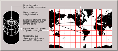
English: Condensed explanation of Mercator-projection maps, converted to SVG format from larger USGS file of GIF format. See enlarged view below, using a wikitable to expand beyond original size.
|
| Date | February 2005 |
| Source | derivative from USGS image file,
|
| Author | derived from US Government USGS |
Enlarged view
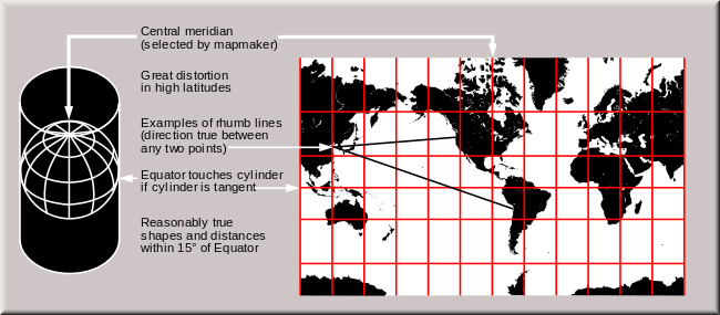 The Mercator projection shows courses of constant bearing as straight lines. While common, scholars advise against using it for reference maps of the world because it drastically inflates the high latitudes. |
Licensing
 |
I, the copyright holder of this work, release this work into the public domain. This applies worldwide. In some countries this may not be legally possible; if so: I grant anyone the right to use this work for any purpose, without any conditions, unless such conditions are required by law.
|
File usage
The following pages on Schools Wikipedia link to this image (list may be incomplete):
Metadata
Find out more
Wikipedia for Schools is one of SOS Childrens Villages' many educational projects. SOS Children believes education is an important part of a child's life. That's why we ensure they receive nursery care as well as high-quality primary and secondary education. When they leave school, we support the children in our care as they progress to vocational training or higher education. We have helped children in Africa for many years - you can help too...